Route Description
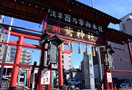
Yoshiwara Nakanocho-dori Ave. Route : Nanbu City Office→Yasaki-inari-jinja Shrine→Kappabashi Dougu Street→Otori-jinja Shrine→Yoshiwara Benzaiten→Yoshiwara-jinja Shrine→Hinodeai Shotengai Shopping Street→Asahi Shotengai Shopping Street→Tamahime Inari-jinja Shrine→Ishihama-jinja Shrine
Ichiyo Memorial Museum Route : Nanbu City Office→Yasaki-inari-jinja Shrine→Kappabashi Dougu Street→Otori-jinja Shrine→Yoshiwara Benzaiten→Yoshiwara-jinja Shrine→Ichiyo Memorial Museum→Hinodeai Shotengai Shopping Street→Asahi Shotengai Shopping Street→Tamahime Inari-jinja Shrine→Ishihama-jinja Shrine
A Word from the Kotobuki Area Health Promotion Committee
■Features of the Kotobuki Area
The Kotobuki area has townscapes leftover since the beginning of the Edo period. Among these is Abekawa, taking its name from the Abe River in Shizuoka, which exists to this day as a town association. Looking west at this town, home to the Magozo Inari Shrine related to Tokugawa Ieyasu, Shinbori-dori Ave. goes north. Kotobuki is the starting point of Asakusa, a cultural center.
* These are estimates given for a person, weight 60kg, moving at 4km per hour, walking 10 min.=30kcal, one step=70cm.
* These are estimates given for a person, weight 60kg, moving at 4km per hour, walking 10 min.=30kcal, one step=70cm.
(1.38MB)
* Some details in the PDF walking map may differ from Google Map.
* Contact regarding the PDF walking map offered on this website.
[Taito City Health Service Section Tel 03-3847-9406]