Route Description
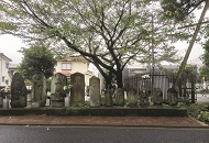
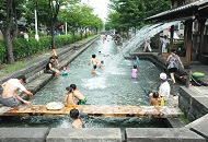
JR Kanamachi Sta., South Exit→Kanamachi Sakae-tori Shotengai Shopping Street→Niijuku Kotsu Park→Koiwa Yosui Greenway→Jizo Bodhisattva Stone Statues→Kaneami-bashi Bridge Ruins→Ichirizuka→Kameari Food Market→Kameari Katori-jinja Shrine→JR Kameari Sta., North Exit
* These are estimates given for a person, weight 60kg, moving at 4km per hour, walking 10 min.=30kcal, one step=70cm.
(0.81MB)
* Some details in the PDF walking map may differ from Google Map.
* This page was created based on information received in January 2023; building names, etc. may differ from the PDF walking map.
* Contact regarding the PDF walking map offered on this website.
[Katsushika City Health part Community health Section Tel 03-3602-1231]