Route Description
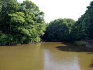
Tadao-koen-mae Bus Stop→Tadao Park→War Memorial Tower→One-ryokudo Road→Yagara-hachimangu Shrine→Sakaigawa Yukkuri Road→Tadao-koen-mae Bus Stop
The One-ryokudo Road, with a total length of about 8 km, was developed as a road for a test run of tanks manufactured by the army armory in the last days of the Pacific War, so it was called “Sensha-doro (road for tanks)” in the past.
After the war, it was used by the Japan Defense Agency (now the Ministry of Defense) for a while, but it was later developed as a walking path that plays a role in building a pedestrian network, together with Sakaigawa Yukkuri Road.
* These are estimates given for a person, weight 60kg, moving at 4km per hour, walking 10 min.=30kcal, one step=70cm.
(1.24MB)
* Some details in the PDF walking map may differ from Google Map.
* Contact regarding the PDF walking map offered on this website.
[Machida City Health Center Health Promotion Dept. TEL 042-724-4236]