Route Description
Oyamada Ryokuchi Service Center→Reservoir, upper pond, lower pond and balancing reservoir→Narabai Yato→Tama Yokoyama-no-michi→Oyamada Ryokuchi Park Yamanaka Area→Suspension bridge→Oyamada Ryokuchi Service Center
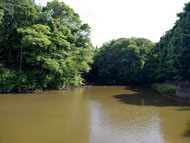
In Tokyo Metropolitan Oyamada Ryokuchi Park, which was developed using the nature of the Tama Hills, you can enjoy walking and observing nature on the pond, the thicket with konara oak, sawtooth oak and bamboo-leaf oak, a bamboo forest, and a grassy open space.
Narabai Yato is a valley area with a traditional agricultural environment, and features forested slopes and farmland in the valley. As a civic collaboration project, satoyama conservation activity is carried out.
* These are estimates given for a person, weight 60kg, moving at 4km per hour, walking 10 min.=30kcal, one step=70cm.
(1.17MB)
* Some details in the PDF walking map may differ from Google Map.
* Contact regarding the PDF walking map offered on this website.
[Machida City Health Center Health Promotion Dept. TEL 042-724-4236]