Route Description
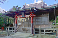
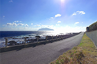
Tsubota→Miyake Village Recreation Center→Viewing the Rock of Tametomo→Ninomiya Shrine→Kaizo-ji Templed→Tsubaki Trees→Tsubota Kannon→Okihara Coast→Tsubota
The Tsubota District is where old-fashioned townscapes remain, and it is a pleasure just walking around. The coastline of about 2.5 km in length located on the sea side of the airport is an exquisite course with views of Mt. Oyama and Mikura Island.
* These are estimates given for a person, weight 60kg, moving at 4km per hour, walking 10 min.=30kcal, one step=70cm.
(3.23MB)
* These courses are listed on P.2 of the PDF Walking Map.
* Some details in the PDF walking map may differ from Google Map.
* Contact regarding the PDF walking map offered on this website.
[Miyake village government office TEL 04994-5-0911]